U.S. Forest Service
Plumtaw Fire objectives:
Fire resources continue to make progress securing the fire perimeter. Crews will mop up to the extent necessary to prevent further fire spread and helicopters remain on stand-by for water drops, crew support and initial attack as needed. Fire crews, aviation resources and equipment will remain on scene until containment objectives are met.
Smoke will be visible as fuels and vegetation continue to smolder and burn within the fire perimeter.
Yesterday’s accomplishments:
Weather:
A cool, cloudy, and breezy pattern persists. Mid-day gusts to 25 mph are expected. Winds will be slightly more westerly.
Fire start date: May 17, 2022
Fire size today: 726 acres
Containment: 12 percent
Location: 7 miles north of Pagosa Springs, Colo.
Personnel: 437
Cause: With no recent lightning and no prescribed fire, the fire’s cause is under investigation.
Management:
Rocky Mountain Complex Incident Management Team 2
10 20-person crews
18 engines
5 water tenders
3 dozers
6 helicopters
1 skidgeon (skidder/engine)
Evacuation Information:
Archuleta County Emergency Operations Call Center
970/422-7084
For the latest Smoke Outlook, visit:
https://outlooks.airfire.org/outlook/1275a044
Plumtaw Fire update, Sunday, May 21, 11:40 a.m.
Size: 721 Acres
Contained: 12 Percent
Plumtaw Fire update, Saturday, May 21, 6 p.m.:
U.S. Forest Service
Plumtaw Fire Objectives:
• To utilize risk management to reduce risks to the public and to firefighters.
• To protect the Lost Valley of the San Juans subdivision and critical infrastructure, including the Fourmile Creek watershed, water intake, private lands and additional infrastructure.
No fire growth occurred yesterday. Smoldering continues to be observed due to the quantity of heavy fuels and heat present.
Yesterday’s accomplishments:
• Due to minimal fire behavior, crews and equipment had a successful and safe day by implementing line construction, establishing hose lays, patrolling and conducting mop-up to meet full suppression objectives.
• Helicopters provided continuous bucket support to crews working on the fire perimeter as large ground fuels are still burning and producing smoke.
• Structure assessments were completed in the Lost Valley of the San Juans subdivision.
Today’s plan:
• Crews will continue establishing hose lays, patrolling and mopping up.
• Engine and crews will continue to be engaged in the Lost Valley of the San Juans subdivision.
• Helicopters will be utilized as needed to support crews with cooling active fire.
Weather:
• Today will be mostly cloudy with continued breezy winds and light morning precipitation. Tonight, scattered rain/snow showers with breezy southwest wind are expected. Warmer, drier weather is anticipated by Wednesday.
According to airport records, the period from April 1 to May 20 was the windiest in the last 30 years. Fire start date: May 17, 2022
Fire size today: 727 acres
Containment: 0%
Location: 7 miles north of Pagosa Springs, CO Personnel: 336
Cause: With no recent lightning and no prescribed fire, the fire’s cause is under investigation.
Management: Rocky Mountain Complex Incident Management Team 2 8 20-person crews
14 engines
5 water tenders
2 dozers
8 helicopters
1 skidgeon
Evacuation Information: Archuleta County Emergency Operations Call Center 970/422-7084
May 20, 10 a.m. update:
Current as of 5/20/2022, 10:00:43 AM Incident Type Wildfire Cause Under Investigation Date of Origin Tuesday May 17th, 2022 approx. 01:00 PM Location 7 miles north of Pagosa Springs, CO Coordinates 37.366 latitude, -107.075 longitude
Weather Concerns Critical Fire Weather
Size 727 Acres Fuels Involved Ponderosa pine, Gambel oak, mixed conifer
May 19, 11:30 a.m. update:
The Plumtaw Fire is burning 7 miles north of Pagosa Springs.
An evacuation notice is still in place for the Lost Valley of the San Juans, located in northern Archuleta and southern Mineral counties, Colo. No further evacuations or pre-evacuations have been ordered.
For evacuation information, contact the Archuleta County Emergency Operations Call Center at (970) 422-7084.
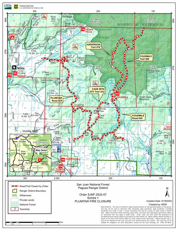
The fire area is closed to the public, per closure order SJN-2022-07. The closure includes Fourmile Road (NFSR 645) at the forest boundary, Plumtaw Road (NFSR 634) from the junction of McManus Road (NFSR 633), Fourmile Trail, Anderson Trail and Cade Mountain ATV Trail.
Yesterday, crews safely and effectively anchored and secured the line off the Fourmile Road and Plumtaw Road. Significant cloud cover helped limit fire behavior and fire retardant application on the north flank kept the fire in check. Today, critical fire weather is expected, with high temperatures, high winds and very low humidity, which may create challenges for firefighters.
Crews worked diligently throughout Wednesday’s operational period and bedded down yesterday evening to prepare for today.
“Fire managers have to practice risk-based decision making and keeping our firefighters and the public safe is the number one priority,” said Incident Commander Brad Pietruszka. “Potential still exists for the fire to cross Fourmile Road, but well-rested crews are better prepared to make good, safe, and effective decisions.”
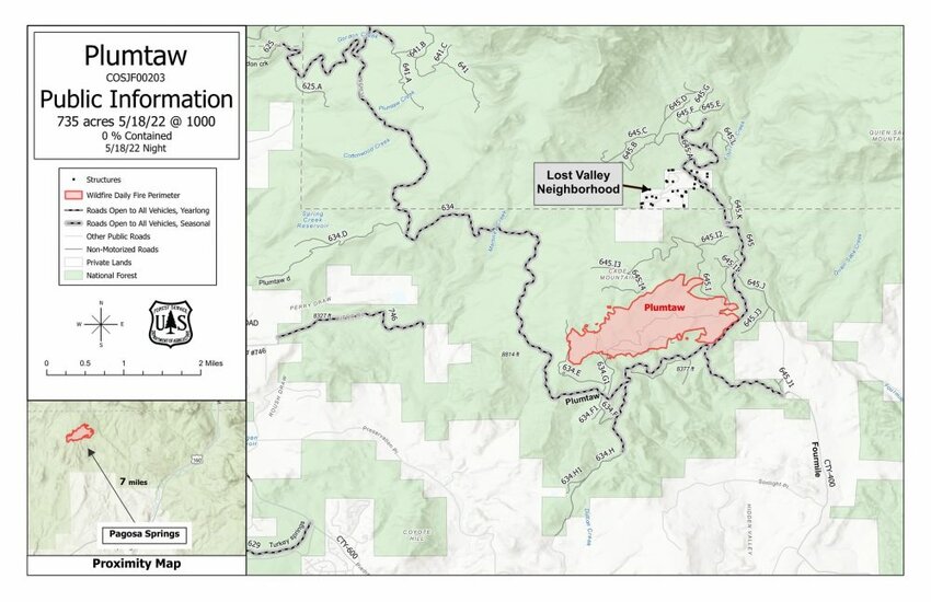
Acres burned: 735
Personnel: 184
Containment: 0%
Cost to date: 1.1 million
The San Juan National Forest will enter Stage 1 Fire Restrictions at 12:01am on Friday, May 20. More information is to come this week on fire restriction implementation.
For regular up-to-date information on the Plumtaw Fire, visit the InciWeb page: https://inciweb.nwcg.gov/incident/8113/ and follow the Plumtaw Fire Facebook page: https://www.facebook.com/PlumtawFire.
Evening update (8:35 p.m. May 18) from USDA Forest Service - San Juan National Forest: The Plumtaw Fire is now 735 acres, following a day with moderate cloud cover that limited fire behavior and provided an opportunity for crews to improve lines. Firefighters met today's primary objective of safely holding the fire west of Fourmile Road and north of Plumtaw Road while developing and implementing structure protection plans for Lost Valley of the San Juans neighborhood.
A standing evacuation order is still in place for Lost Valley of the San Juans.
The next two days may bring challenges to Plumtaw Fire resources, as a red flag warning is predicted to bring high winds and low relative humidity to the area.
Previous information:
By Randi Pierce | Staff Writer
As of approximately 8 p.m. on Tuesday, May 17, the Plumtaw Fire — identified earlier in the day — had grown to more than 600 acres and evacuation notices had been issued for residents of the Lost Valley of the San Juans subdivision in Mineral County.
At 10 a.m. on Wednesday, May 18, the fire was mapped via infrared satellite imagery at 613 acres.
The fire, according to a press release from the U.S. Forest Service, San Juan National Forest, is burning 7 miles north of Pagosa Springs, 2 miles west of the intersections of Plumtaw and Fourmile roads.
According to the press release, the Forest Service was notified of the fire at approximately 1 p.m. on May 17 and it is burning in ponderosa pine, Gambel oak and mixed conifer.
The cause of the fire, it notes, remains under investigation.
A Tuesday afternoon press release explains, “Overnight, the fire backed down to within 150 feet of Fourmile Road (NFSR 645). Firefighters sent a low-intensity fire from the road to meet the oncoming fire to create a buffer, an operation known as a ‘burn out.’ This strategic tool will allow for better visibility during the day and provide opportunities to work off Fourmile Road as a holding line. Hazardous fuels treatments completed in 2021 along the Fourmile Road helped crews hold the fire at that road.”
On Wednesday, the press release notes, fire personnel focused efforts on the northeast corner near Fourmile Road (Forest Service Road 645), protecting the Fourmile Creek watershed and Lost Valley of the San Juans subdivision, and keeping the fire north of Plumtaw Road (Forest Service Road 634).
On Tuesday, the Forest Service reported that multiple large air tankers, one lead plane, an air attack platform and three helicopters were working with ground crews on the fire.
A Type 3 incident management team took command of the incident Wednesday morning and a complex incident management team has been ordered, along with additional resources and crews, a Tuesday press release explains.
“Resources from multiple state, federal, county, and municipal agencies are working in close coordination,” it states.
More information about the fire is available at https://inciweb.nwcg.gov/incident/8113/ and updates will be posted via www.PagosaSUN.com and The SUN’s Facebook pages.
Evacuation information
The Lost Valley of the San Juans neighborhood, located in Mineral County, was evacuated Tuesday afternoon due to the fire.
As of shortly after 2 p.m. on Wednesday, no other evacuations or pre-evacuation notices were in place, according to a U.S. Forest Service press release.
Evacuation information is available by calling the Archuleta County Emergency Operations Call Center at (970) 422-7084.
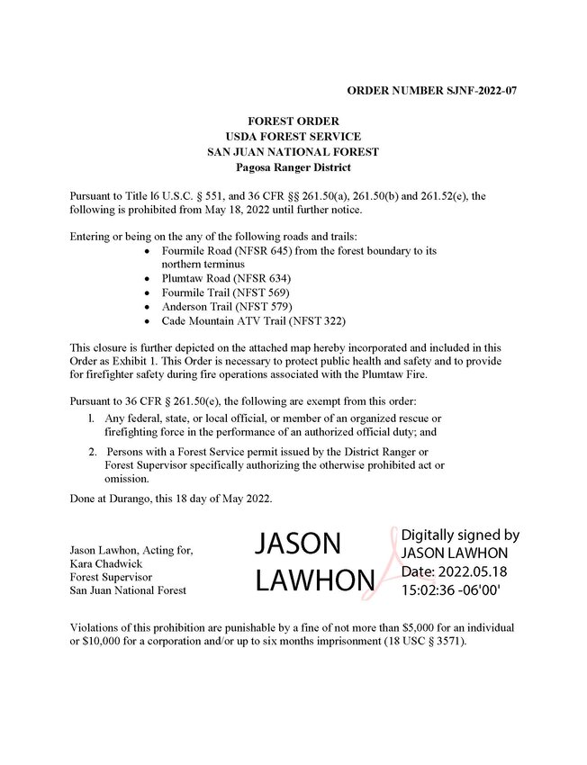
Fire area closed
The fire area is closed to the public, including Fourmile Road (Forest Service Road 645) at the forest boundary and Plumtaw Road (Forest Service Road 634) from the junction of McManus Road (Forest Service Road 634).
The closure includes the Fourmile Falls Trailhead.
For information on the San Juan National Forest, call (970) 247-4874, visit the forest website, or follow it on social media (Twitter and Facebook).
Weather concerns
The Plumtaw Fire’s InciWeb page lists a trio of weather concerns: “Hot, Dry, Windy.”
The National Weather Service issued a red flag warning for 11 a.m. to 10 p.m. today, Thursday, May 19.
“Conditions will become favorable for easy ignition and rapid spread of fires due to low relative humidity and strong gusty winds,” it states, adding later, “A combination of strong winds, low relative humidity and warm temperatures can contribute to extreme fire behavior.
The warning lists winds southwest 20 to 30 mph with gusts up to 50 mph and relative humidity at 8 to 13 percent.
How to sign up for
emergency alerts
Citizens can sign up for emergency alerts from Archuleta County at: https://www.archuletacounty.org/569/Citizens-Alert.
Air-quality advisory
issued
On Wednesday morning, San Juan Basin Public Health (SJBPH) announced that the fire triggered unhealthy air quality in northern Archuleta County and southern Mineral County.
It noted that air-quality sensors, including two operated by San Juan Basin Public Health in Archuleta County indicated “unhealthy” to “very unhealthy” air quality.
Visit https://fire.airnow.gov/ for the most up-to-date information.
“If smoke is thick or becomes noticeably thicker in your area you should remain indoors or if possible seek out locations where air is filtered,” the press release notes. “Unusually sensitive people throughout the region should reduce prolonged or heavy exertion.”
It further explains that if visibility is less than 5 miles, smoke has reached levels that are unhealthy.
“This is especially true for those with heart disease, respiratory illnesses, the very young, and the elderly,” it states. “Consider limiting outdoor activity when moderate to heavy smoke is present. People with heart or lung disease, older adults, and children should avoid prolonged or heavy exertion; Consider relocating temporarily if smoke is present indoors and is making you ill.”
The press release also includes other tips to protect yourself:
• Close windows and doors and stay inside. However, do not close up your home tightly if it makes it dangerously warm inside.
• Only if they are filtered, run the air conditioning, your evaporative cooler or the fan feature on your home heating system (with the heat turned off). Keep the outdoor air intake closed and be sure the filter is clean. Filtered air typically has less smoke than the air outdoors. Running these appliances if they are not filtered can make indoor smoke worse.
• Use HEPA room air filtration units if you have them.
• Avoid smoking and/or secondhand smoke, vacuuming, candles and other sources of additional air pollution.
• Do not use paper dust masks; these do not filter out the particles and gasses in smoke.
As temperatures cool in the evening, inversion conditions worsen and smoke in low-lying areas may become thicker, especially if the outdoor air is still. It tends to be worst near dawn.
SJBPH recommends closing bedroom windows at night.
“To prepare for nighttime smoke, consider airing out your home during the early or middle of the afternoon when smoke tends to be more diluted,” the press release explains. “Use your best judgment. If smoke is thick during the day, follow the tips above.”


