Hazardous Weather OutlookNational Weather Service Grand Junction CO
330 AM MST Sat Dec 31 2022
COZ001>014-017>023-UTZ022>025-027>029-011030-
Lower Yampa River Basin-Central Yampa River Basin-
Roan and Tavaputs Plateaus-Elkhead and Park Mountains-
Upper Yampa River Basin-Grand Valley-Debeque to Silt Corridor-
Central Colorado River Basin-Grand and Battlement Mesas-
Gore and Elk Mountains/Central Mountain Valleys-
Central Gunnison and Uncompahgre River Basin-
West Elk and Sawatch Mountains-Flat Tops-
Upper Gunnison River Valley-Uncompahgre Plateau and Dallas Divide-
Northwest San Juan Mountains-Southwest San Juan Mountains-
Paradox Valley/Lower Dolores River-
Four Corners/Upper Dolores River-Animas River Basin-
San Juan River Basin-Southeast Utah-Eastern Uinta Mountains-
Eastern Uinta Basin-Tavaputs Plateau-Arches/Grand Flat-
La Sal and Abajo Mountains-Canyonlands/Natural Bridges-
330 AM MST Sat Dec 31 2022
This hazardous weather outlook is for eastern Utah and western
Colorado.
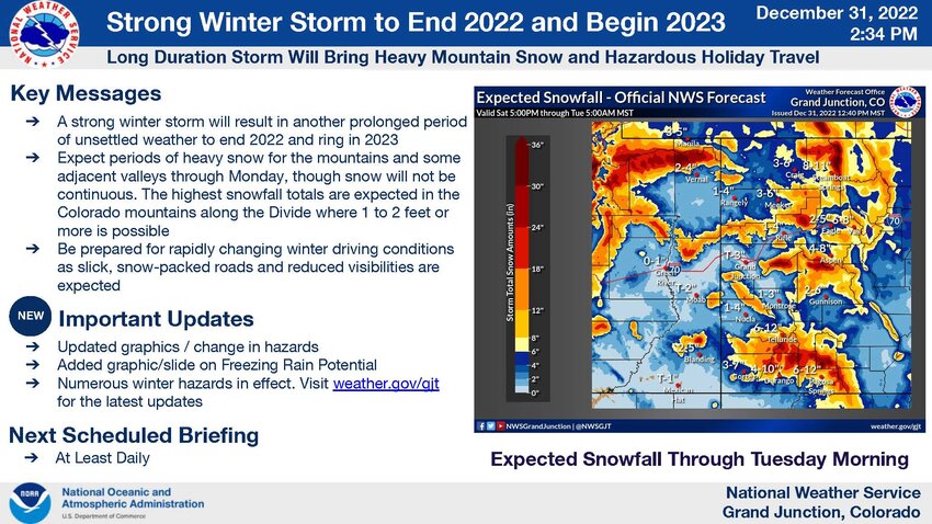
.DAY ONE...Today and Tonight
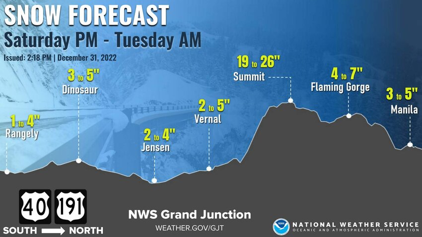
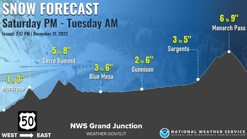
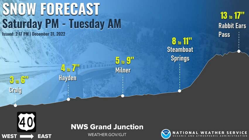
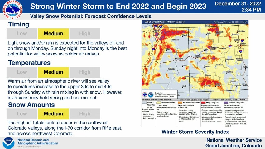
Snow will continue across the area through the day today, with the
main focus on the higher terrain of eastern Utah and western
Colorado. Mountain highlights remain on track. Winter highlights
for the valleys may be needed, but current forecasted snow
amounts remain under highlight criteria. Travel will be difficult
throughout the day.
.DAYS TWO THROUGH SEVEN...Sunday through Friday
A brief lull is expected through early Sunday before the second
heavy push of precipitation associated with the main low moves in
for Sunday night through Monday night. Most areas can expect to
see snow from this system. A weak system will follow on the heels
of this one, skirting to the south and affecting the San Juans.
The next system moves into the Great Basin late this week.
.SPOTTER INFORMATION STATEMENT...
Spotter activation will not be needed.
$$
URGENT - WINTER WEATHER MESSAGENational Weather Service Grand Junction CO
151 PM MST Sat Dec 31 2022
COZ019-011400-
/O.CON.KGJT.WS.W.0014.000000T0000Z-230103T0100Z/
Southwest San Juan Mountains-
Including the cities of Silverton, Rico, and Hesperus
151 PM MST Sat Dec 31 2022
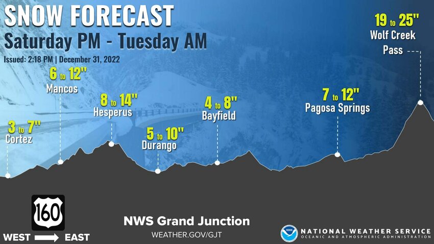
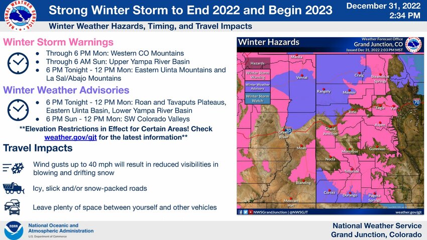
...WINTER STORM WARNING REMAINS IN EFFECT UNTIL 6 PM MST MONDAY...
* WHAT...Heavy snow expected. Total snow accumulations of 1 to 2
feet with locally higher amounts up to 3 feet possible. Winds
gusting as high as 40 mph.
* WHERE...Southwest San Juan Mountains.
* WHEN...Until 6 PM MST Monday.
* IMPACTS...Travel could be very difficult to impossible. Patchy
blowing snow could significantly reduce visibility. A detailed
map of the snowfall can be found at:
www.weather.gov/gjt/winter.
* ADDITIONAL DETAILS...Expect periodic breaks in showers as well
as decreased intensity at times.
PRECAUTIONARY/PREPAREDNESS ACTIONS...
If you must travel, keep an extra flashlight, food, and water in
your vehicle in case of an emergency.
The latest road conditions for the state you are calling from can
be obtained by calling 5 1 1.
&&
$$
COZ010-018-019-034-060-066>068-020015-BULLETIN - IMMEDIATE BROADCAST REQUESTED
AVALANCHE WATCH
COLORADO AVALANCHE INFORMATION CENTER
RELAYED BY NATIONAL WEATHER SERVICE DENVER/BOULDER CO
502 PM MST FRI DEC 30 2022
THE FOLLOWING MESSAGE IS TRANSMITTED AT THE REQUEST OF THE
COLORADO AVALANCHE INFORMATION CENTER.
...AVALANCHE WATCH IN EFFECT FROM 5 PM SATURDAY UNTIL 11 PM
MONDAY...
*WHAT...The Avalanche Danger will rise to HIGH (Level 4 of 5) by
Saturday evening. Very dangerous avalanche conditions expected.
*WHERE...The Elk Mountains, San Juan Mountains, Sawatch Range, Gore
Range, Rabbit Ears Range, Medicine Bow Mountains and Never Summer
Range
*WHEN...Expect very dangerous avalanche conditions to begin Saturday
evening and last through Monday evening in the North and Central
Mountains. Very dangerous avalanche conditions start on Sunday in
the Southern Mountains.
*IMPACTS...Heavy snow and strong winds will create dangerous
avalanche conditions by Monday night. Large and dangerous avalanches
will be easy to trigger once the new snow accumualtes. Avalanches
will run naturally.


