Parts of Pagosa Country received more than 2.5 inches of precipitation from Thursday, June 20, to Monday, June 24, according to data from Community Collaborative Rain, Hail and Snow Network (CoCoRaHS).
During that time frame, downtown Pagosa Springs received 2.68 inches of precipitation.
The southern portion of Archuleta County, near Chromo, received the most, with 2.78 inches of precipitation, according to CoCoRaHS.
In the Aspen Springs area, totals ranging from 1.71 inches to 2.38 inches of precipitation were reported. Areas around Hatcher Lake reported totals ranging from 1.13 inches to 1.38 inches.
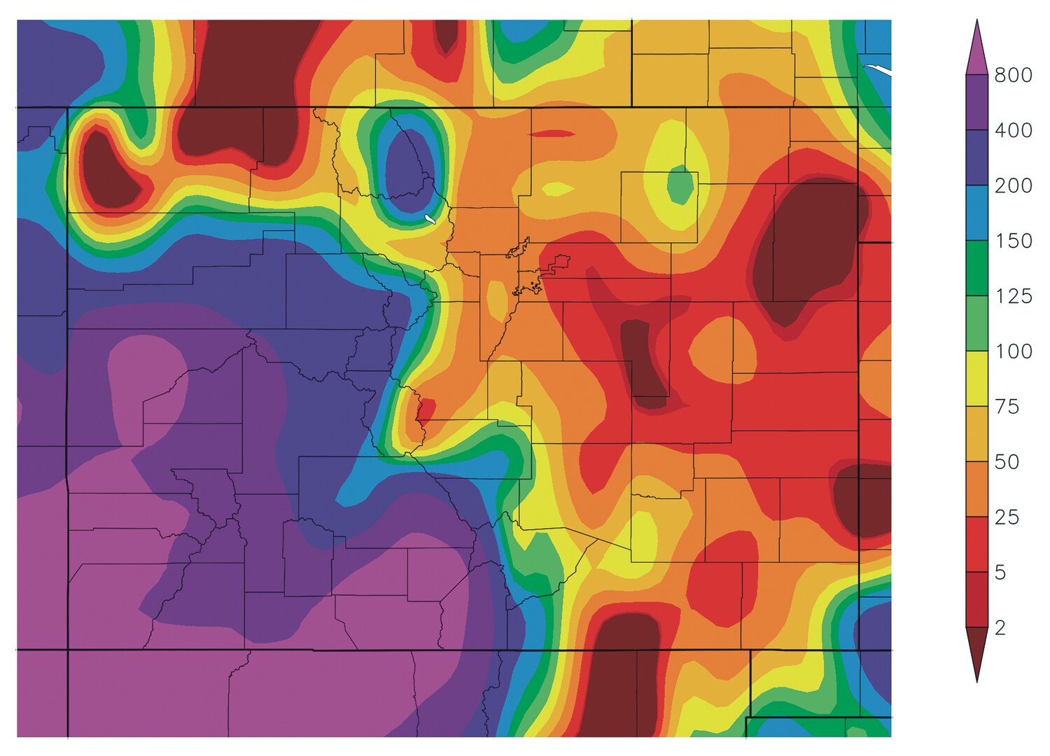
According to data from the High Plains Regional Climate Center (HPRCC), precipitation received from June 18 through June 25 in Archuleta County ranges from 400 to 800 percent of the normal precipitation for those dates.
The same applies for much of southwest Colorado including La Plata County, Mineral County, Hinsdale County and Conejos County, according to the HPRCC.
Drought
As for current drought conditions, as of June 20, 73.75 percent of Archuleta County is in a moderate drought stage, with the remaining 26.25 percent in an abnormally dry stage, according to the U.S. Drought Monitor.
At the start of the current calendar year, 93.16 percent of Archuleta County was in a severe drought stage, according to the U.S. Drought Monitor.
As of June 20, 56.65 percent of the state, mostly in the central, northeast and northwest portions, are not in any stage of drought, according to the U.S. Drought Monitor.
Forecast
Chances of precipitation are expected to continue into this weekend, with the National Weather Service (NWS) forecasting a 10 percent chance of showers after noon tomorrow, Friday, June 28. Temperatures are expected to reach a high of 83 degrees and a low of 48 degrees.
On Saturday, June 29, the high is forecast at 87 degrees and the low at 52 degrees with chances of showers and thunderstorms after midnight.
A chance of showers and thunderstorms is also forecast throughout the day on Sunday, June 30, with a high of 82 degrees and a low of 53 degrees.
According to a report from Shawn Prochazka from Pagosa Weather on June 22, over the next two weeks a subtropical high will try to set in over the southern plains, providing moisture to surge into our area, “just as it should during the monsoon season.”
Prochazka also notes there is a chance for scattered showers and thunderstorms nearly every day during that time period.
“This is how our monsoon should look,” Prochazka writes.
According to the NWS, much of the interior portion of the country is expected to receive above-average precipitation from June 28 through July 2.
This includes areas from New Mexico up through the Rocky Mountains to Montana and across the Great Plains from Minnesota down through areas of Texas.
clayton@pagosasun.com


