Saturday, May 28, 2022, 8:00 a.m.
Type 3 Incident Management Team | Ed LeBlanc, Incident Commander
Special Note: Today at 6 a.m., Type 3 Incident Management Team assumed command of the Plumtaw Fire. Incident Commander, Ed LeBlanc commended the Rocky Mountain Incident Management Team 2 for their quality work and smooth transition.
Divisions A and Z were combined becoming Division A/Z and Divisions D and X were combined becoming Division D/X. This is a common practice as the fire size remains stable, containment increases and fire fighting resource are released.
Current Situation: As expected, fire activity remained consistent with the past few days and no fire growth occurred. Uncontained fireline in the northeast corner remains the highest priority and crews continued to secure firelines by extinguishing heat sources and removing fuels. On contained firelines, firefighters conducted patrol and mop-up operations, backhauled unneeded supplies and equipment, and conducted suppression repair operations.
Today, as weather conditions allow, the bulk of resources will be working again in the northeast corner continuing with suppression operations. Fire crews will contend with windy conditions and gusts up to 50 mph which will present additional hazards and may limit support from air operations. On contained sections, firefighters will continue to repair primary and secondary firelines by removing debris and branches that were cut during fireline construction and will also conduct other suppression repairs to prevent topsoil loss during future rainstorms. Patrol and mop-up and planning for suppression repair will continue on sections of lines that aren’t ready for suppression repair. Looking ahead, fire managers are optimistic that firefighters will connect and strengthen firelines leading to increased containment.
Weather and fuel conditions: Today, there is a Fire Weather Watch in effect from 11 a.m. to 10 p.m. Weather conditions are expected to be warm, dry and windy with temperatures above normal in the mid to high 70s, humidity around 12 percent, and winds at 20-25 mph with gusts up to 45 mph. Critical burning conditions will exist especially in interior pockets of unburned fuels although fire is not expected to spread outside of existing containment lines.
Closures and advisories
Areas around the fires are closed for public safety. Please respect the closure signs.
Temporary flight restrictions (TFRs) remain in place on all three fire areas. TFR violations can disrupt aerial firefighting operations and may force fire managers to ground essential aircraft. Wildfires are a no-fly zone for unauthorized aircraft, including drones. If you fly, we can’t. http://knowbeforeyoufly.org
Stage 1 fire restrictions remain in place for the San Juan National Forest. There is also a closure area for the Plumtaw fire. See: https://www.fs.usda.gov/alerts/sanjuan/alerts-notices
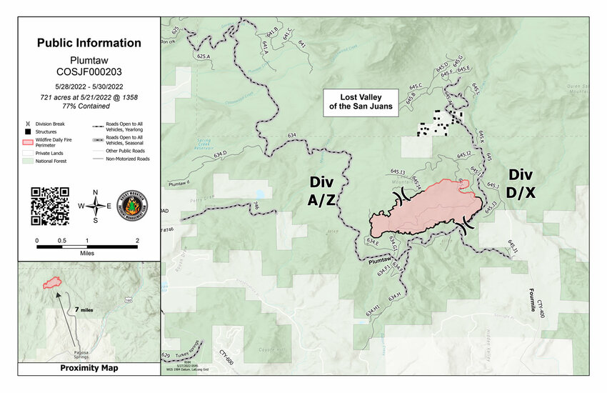
Plumtaw Fire Statistics: Size: 721 acres Containment: 77%
Total Personnel: 226
Reported: May 17
Cause: Under investigation For More Information: Public Information (970) 316-2594
Public email: 2022.plumtaw@firenet.gov
InciWeb: Plumtaw Fire Information - InciWeb the Incident Information System (nwcg.gov) Facebook: Plumtaw Fire - Home | Facebook
Previous update from Friday, May 27: Plumtaw Fire command to transfer to San Juan National Forest: 72 percent containment
Plumtaw fire objectives continue to be met enabling the Rocky Mountain Incident Management Team 2 to transfer command of the Plumtaw Fire to the San Juan National Forest on Saturday, May 28, at 6 a.m.
In preparation for the Memorial Day weekend, recreationists are reminded of the trail and road closures near the fire area. Drone pilots must observe the Temporary Flight Restrictions (TFR) and not fly inside the fire’s airspace.
Yesterday’s accomplishments:
Fire start date: May 17, 2022
Fire size today: 721 acres
Containment: 72 percent
Location: 7 miles north of Pagosa Springs, Colo.
Personnel: 364
Cause: With no recent lightning and no prescribed fire, the fire’s cause is under investigation.
Management: Rocky Mountain Complex Incident Management Team 2
6 20-person crews
6 engines
2 water tenders
1 dozer
2 helicopters
1 skidgeon (skidder/engine)
San Juan National Forest Closure Information: https://www.fs.usda.gov/alerts/sanjuan/alerts-notices TFR# ZDV2/5953
Drones: Drones are hazards for our pilots and ground crews. Remember: If You Fly, We Can’t!
Previous update: Plumtaw Fire remains at 721 acres: 62 percent containment
By Randi Pierce | Staff Writer
As of Wednesday, May 25, the Plumtaw Fire had burned 721 acres 7 miles north of Pagosa Springs, 2 miles west of the intersections of Plumtaw and Fourmile roads.
The fire is believed to have started May 17. By that evening, it was estimated to have burned more than 600 acres, with that number refined to 613 acres the following day.
By May 19, it was estimated at 735 acres.
But, despite multiple days of wind and critical fire weather, the estimated acreage of the fire then shrunk as more mapping on the active part of the fire was done, with updates estimating the fire at 727 acres, then 726, then 721.
May 12 was the first day any part of the fire was determined to be contained, with reports showing 12 percent containment that day.
As of Wednesday morning, the fire continued to be 721 acres, with 62 percent containment.
The fire’s estimated containment date is July 15.
According to Beau Kidd, operations section chief on the fire, several factors go in to determining when the fire might be contained.
“There are portions of this fire that have potential for reburn as the fuel dries out,” he said. “There’s green vegetation that’s far within the perimeter which could pose a threat to fire escaping that perimeter if things dry out and the wind lines up perfectly. So, that’s the reason for the extended — we don’t like to say it’s contained and then something flares up a month down the road and then all of a sudden it’s not contained anymore.”
As of Wednesday, Rocky Mountain Incident Management Team 2, which is currently managing the fire, reported that there are 461 personnel assigned to the fire, though excess resources will be released and reassigned to other fires when they are no longer needed to meet objectives on the Plumtaw Fire.
It also states air resources are available for initial attack in other areas of the region.
About 250 of the 461 people assigned to the fire Tuesday were firefighters working at the fire, Kidd noted.
Wednesday’s update from the management team notes the fire objectives are to “utilize risk management to reduce risks to the public and to firefighters” and “protect the Lost Valley of the San Juans subdivision and critical infrastructure, including the Fourmile Creek watershed, water intake, private lands, and additional infrastructure.”
The update also indicates that mop-up operations are continuing on the fire.
“Mop up operations will continue through the week as resources work along the fire’s controlled edge, beyond the perimeter, and into the interior,” Wednesday’s update states.
On Tuesday, officials on the fire discussed how the fire behaved in the southern and eastern sections, where mop-up and rehabilitation work is underway.
“If you look at the majority of the trees, you don’t see a lot of burned all the way to the top, so that indicates to us this was a surface fire,” Erin Doyle, division supervisor for the south side of the Plumtaw Fire, said. “So, it was burning the pine needles, the leaves, some of the dry grasses. You can still see areas where the green grass is unconsumed. Under most of the coniferous trees, you see, like, complete consumption, so that would be the dried pine needles, the sticks and the years of duff that have accumulated. So, in some ways that would be desirable, removing some of those sort of fuels from the forest system, so that’s a good thing.”
Doyle explained that firefighters use existing control features, such as roads or rivers, and will reinforce those to stop the surface spread of the fire.
In the case of the Plumtaw Fire, Doyle pointed out a fence line on the southern flank of the fire where an easement is in place and a bulldozer was used to remove organic material and reduce the spread of the fire on the surface.
“This is the ideal situation for this kind of suppression effort because in a surface fire spread that simple separation of fuels really minimizes the potential for fire to move,” he said.
Once the fire moves into the canopy, he added, a control feature like that or a road “is a moot point.”
In other places where a dozer can’t go, a hand crew will work to remove the fuels along the fire’s edge to minimize its spread along the ground.
Doyle also pointed out mop-up work and rehabilitation underway along the southern flank.
Kidd and Doyle explained that crews will use a grid approach in performing mop-up work on the fires, with crews working in a pattern to check for hot spots and residual heat that could reignite and burn unburned vegetation, with those spots then extinguished using water pumped through hoses.
That work is done a few times a day, they explained, and drones and flights with thermal infrared detection capabilities help find hotspots.
Nearby, firefighters were removing fire lines in areas where there is no threat to containment on Tuesday, redistributing material that was removed and helping prevent erosion.
“On the steeper slopes, it’s a pathway for water to really gain some momentum and cause some erosion damage, so that’s important,” Kidd said, adding they’ll put in water bars to divert the water to areas with vegetation.
Remediation of the fire site, Kidd and Public Information Officer Laura Lozier suggested, will likely continue for a long time and could include planting around monsoon season, weed management and more.
“With no recent lightning and no prescribed fire, the fire’s cause in under investigation,” the update states.
More information about the fire is available at https://inciweb.nwcg.gov/incident/8113/ and updates will be posted via www.PagosaSUN.com and The SUN’s Facebook pages.
More photos can be viewed at www.PagosaSUN.com.
‘It’s time for people to be aware of what’s possible’
“So, there’s two different things going on here with this fire,” Kidd explained. “So, you have the dead fuels that are on the ground — the big logs — the moistures in those fuels are very, very low right now. And then you have the live fuels, specifically like the oak brush, that’s just startin’ to pull moisture up from the ground and shoot those leaves out, so it’s coming out of dormancy, and so it’s not to a point now where it’s volatile enough to really burn unless it gets a good flash of heat comin’ through it.”
The logs, Kidd, explained, are what is carrying the fire right now.
“If this fire was, I dunno, late June, it would be a whole different ball game,” he said. “The oak would be available to burn completely, and so that would add to the fuel profile. And so you’d have more resistance to control, probably faster fire spread, so it’d be a lot more challenging.”
“As for fire behavior in Colorado in May, being that this is some of our moisture-gaining months of the year, this is unusual, for sure, to see this scale of fire burning,” Doyle said.
Whether or not this is an indicator of things to come, Doyle suggested, depends on the weather in the next couple of weeks.
“It’s time for people to be aware of what’s possible for 2022 until the monsoons come and start to have their beneficial side of things.”
Earlier in the day Tuesday, fire personnel attended the Archuleta County Board of County Commissioners’ work session.
At that work session, incident meteorologist Chip Redmond told the board, “It’s been dry. It’s been warm. But, most importantly, it’s been windy.”
Looking at the statistics from the beginning of April until now, he told the commissioners, this has been the windiest “it’s ever been,” both here and in Durango.
He also discussed the lack of moisture recently, the quick snow melt, wind in the forecast and expected above-average temperatures through June.
Those in attendance also talked about how beneficial the initial response to the fire was.
Evacuation information
As of Wednesday afternoon, the Lost Valley of the San Juans neighborhood, located in Mineral County, remained evacuated.
Evacuation information is available by calling the Archuleta County Emergency Operations Call Center at (970) 422-7084.
Fire area closed
The fire area is closed to the public, including Fourmile Road (Forest Service Road 645) at the forest boundary and Plumtaw Road (Forest Service Road 634) from the junction of McManus Road (Forest Service Road 634).
The closure includes the Fourmile Falls Trailhead.
For information on the San Juan National Forest, call (970) 247-4874, visit the forest website, or follow it on social media (Twitter and Facebook).
How to sign up for
emergency alerts
Citizens can sign up for emergency alerts from Archuleta County at: https://www.archuletacounty.org/569/Citizens-Alert.
randi@pagosasun.com


